|
|
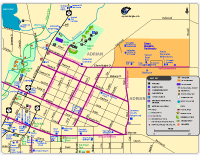
Downtown Adrian Map (Online version)
Downtown Adrian Map (PDF)
Trails included: Historical Walking Route, Kiwanis Trail and Trestle Park Boardwalk.
Bike Routes included: Wide-shoulder bike routes along Bristol Street, Broad Street, Comstock Park, Dean Street, Division Street, Maple Avenue, Maumee Street, Ornsby Street, and Siena Heights Drive.
Parks included: Adrian Skate & Bike Park, Berry Park, Erie Street Park, Island Park, McFarland Park, Monument Park, Trestle Park, and Yew Park.
Also shows Adrian City Hall, City Chambers, Croswell Opera House, Lenawee County Historical Museum, Siena Heights University, farmers market, library, post office, restaurants, stores, schools, historical markers, and more in downtown Adrian, Michigan.
|

|
|
|
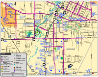
Adrian Map (Online version)
Adrian Map (PDF)
Parks included: Berry Park, Burr Ponds Park, Comstock Park, Dana Park, Erie Street Park, Fee Park, McFarland Park, Monument Park, Riverside Park, Trestle Park.
Trails included: Burr Ponds Park Trail and Kiwanis Trail.
Bike Routes: the shoulder bike routes along Ann Arbor Trail and Ann Arbor Road.
Also shows Adrian College, Croswell Opera House, courthouse, library, fairgrounds, schools, restaurants, stores, churches, historical markers, and more.
|
|
|
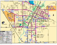
Adrian Area Bike Routes Map (Online version)
Adrian Area Bike Routes Map (PDF)
Shows streets with bike lanes and wide street lanes that can be used for biking in Adrian. On the streets with wide lanes, there are sometimes parked cars on the side of the street, so you'll need to slow down and go around the cars. Always use caution and obey traffic laws when riding on the side of the street.
Also shows many locations in Adrian.
|
|
|
|
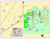
Adrian Heritage Park Map (Online version)
Adrian Heritage Park Map (PDF)
Heritage Park has trails for biking and hiking. The park has softball diamonds, soccer fields, a remote controlled airplane field, disc golf course, picnic shelters, a playscape, and sledding hill. Stubnitz Environmental Education Center, the old Freesoil School, and old barber shop.
The map also shows the Adrian Skatery and the Adrian Cinema.
|