|
|
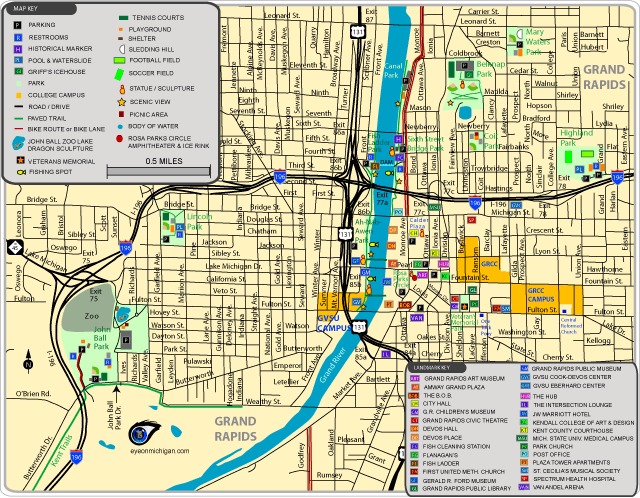
Downtown Grand Rapids MapParks included: Ah-Nab-Awen Park, Belknap Park, Coit Park, Fish Ladder Park, Highland Park, John Ball Park, Lincoln Park, Mary Waters Park, Rosa Parks Circle, Sixth Street Bridge Park, and Veteran's Memorial Park.
Attractions included: Calder Plaza, DeVos Hall, DeVos Place, Flanagan's, Gerald R. Ford Museum, Grand Rapids Art Museum, Grand Rapids Civic Theatre, Grand Rapids Children's Museum, Grand Rapids Public Library, Grand Rapids Public Museum, Intersection Lounge, John Ball Park Zoo, One Trick Pony, St. Cecilia's Musical Society, The B.O.B., and Van Andel Arena.
Also shows Amway Grand Plaza, Grand Rapids Community College, Grand Valley State Univeristy's, Grand Rapids campus, JW Marriott Hotel, Kendall College of Art & Design, Michigan State University's medical campus, and more.
Maps of Grand Rapids, MichiganView maps of trails, parks, attractions, and more in Grand Rapids by clicking a link for the online version (GIF) and PDF version. PDF versions are full-page maps, saved at a higher resolution.
|
|
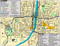
Downtown Grand Rapids Map (Online version)
Downtown Grand Rapids Map (PDF)
Parks included: Ah-Nab-Awen Park, Belknap Park, Coit Park, Fish Ladder Park, Highland Park, John Ball Park, Lincoln Park, Mary Waters Park, Rosa Parks Circle, Sixth Street Bridge Park, and Veteran's Memorial Park.
Attractions included: Calder Plaza, DeVos Hall, DeVos Place, Flanagan's, Gerald R. Ford Museum, Grand Rapids Art Museum, Grand Rapids Civic Theatre, Grand Rapids Children's Museum, Grand Rapids Public Library, Grand Rapids Public Museum, Intersection Lounge, John Ball Park Zoo, One Trick Pony, St. Cecilia's Musical Society, The B.O.B., and Van Andel Arena.
Also shows Amway Grand Plaza, Grand Rapids Community College, Grand Valley State Univeristy's, Grand Rapids campus, JW Marriott Hotel, Kendall College of Art & Design, Michigan State University's medical campus, and more.
|

|
|
|
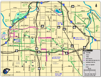
Northern Grand Rapids Map (Online version)
Northern Grand Rapids Map (PDF)
Parks included: Briggs Park, Richmond Park, and Riverside Park.
Trails and Bike Routes: Shows the trailhead for the Fred Meijer White Pine Trail, the trail through Riverside Park, and bike routes along Knapp Street and Monroe Avenue.
|
|
|
|
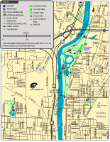
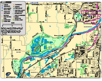
Grand Rapids Trails Map (Online version)
Grand Rapids Trails Map (PDF)
This summary map shows the locations of Cascade Pathways, Grandscapes Trail, Kent Trails, M-6 Trail, Paul Henry Trail, and Plaster Creek Trail. Bike routes, sidewalk routes and walking/jogging routes are also shown. Only major roads are on this map. You will want to view the web pages for the individual trails for more detail.
|
|
|
|
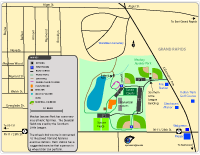
Mackay Jaycees Park Map (Online version)
Mackay Jaycees Park Map (PDF)
Mackay Jaycees Park is located north of 28th Street and features baseball diamonds, soccer fields, tennis courts, basketball courts, and a large playground. The park also has a short trail that winds through the park.
The map also shows the locations of Indian Trails Golf Course, Meijer, and Walgreens.
|
|
|
|
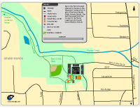
Kenosha Park Map (Online version)
Kenosha Park Map (PDF)
Ken-O-Sha Park is located west of Kalamazoo Avenue. It serves as a trailhead for the Plaster Creek Trail.
|
|
|
|
Kent Trails - Wyoming/Grand Rapids Segment Map (Online version)
Kent Trails - Wyoming/Grand Rapids Segment Map (PDF)
Shows the Kent Trails segment north of 28th Street/M-11. The trail connects to the bike route along Indian Mounds Drive, crosses the Grand River using an old railroad bridge, goes to Millenium Park, and then ends at John Ball Park.
The map also has the trails and facilities at Johnson Park, Millenium Park, Lamar Park, Pinery Park, and Battjes Park.
|
Also see:
- Cascade Pedestrian Pathways
- East Beltline Area Trails
- Kent Trails
- Fred Meijer M-6 Trail
- Paul Henry Thornapple Trail
- Plaster Creek Trail
- Reeds Lake Area Trail & East Grand Rapids Trails
- Fred Meijer White Pine Trail
|
|