|
|
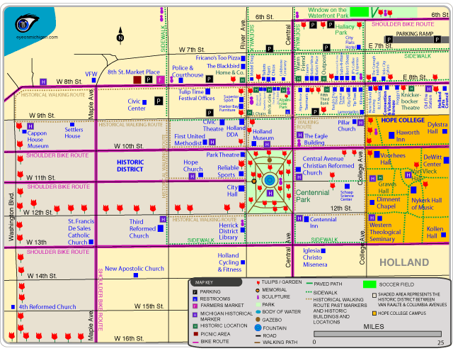
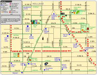
Downtown Holland MapAttractions shown: Cappon House Museum, Civic Center, Holland Civic Theatre, Holland Museum, Hope College, Knickerbocker Theatre, and Park Theatre.
Parks included: Centennial Park, Hallacy Park, and Window on the Waterfront Park. There are two small pocket parks on 8th Street that feature sculptures.
Walking and Jogging Routes: The Historical Walking Routes will take you past historic locations and historical markers. There are rectangular markers posted on the several buildings, such as the Warm Friend Building and Fifth Third Bank Building, that describe when the building was constructed and other details. You can also visit many restaurants, stores and other locations in Holland via sidewalk.
Bike Routes: The bike routes shown are on streets that either have designated bike routes or have wide road lanes where cyclists can ride on the outside part of the lane.
Also shows Centennial Inn, City Flats Hotel, Eagle Building, Haworth Inn, Eighth Street Market, Herrick District Library, Holland City Hall, Holland Cycling & Fitness, Tulip Time Offices, City Flats Hotel, Convention & Visitors Bureau, Velo City Cycles, historic district, historical markers, sculpture locations, tulip garden locations, stores, restaurants, and more in Holland.
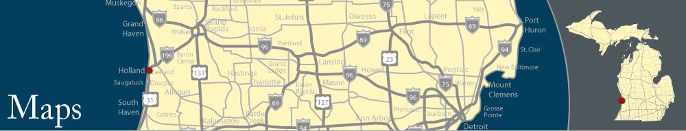
Maps of Holland, MichiganView maps of tulip routes, trails, bike routes, parks, restaurants, stores, historic locations, and more in Holland by clicking a link for the online version (GIF) and PDF version. PDF versions are full-page maps, saved at a higher resolution.
|
|
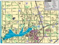
Holland Map (Online version)
Holland Map (PDF)
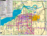
Attractions shown: Civic Center, Craig's Cruisers, Holland Civic Theatre, Holland Community Aquatic Center, Holland Municpal Stadium, Holland Museum, Hope College, Knickerbocker Theatre, and Park Theatre, Windmill Island.
Bike Routes shown: Shows streets with either designated bike routes or wide road lanes that have room for bikes to ride on the outside of lanes.
Tulip Routes shown: In the spring, you'll see tulips along many streets, including 8th Street, 16th Street, 28th Street, Central Avenue, State Street, Van Raalte Avenue, and Washington Boulevard.
Trails shown: Part of Holland paved trail system, Dunton Park Boardwalk, Heinz Waterfront Walkway, Window on the Waterfront Trail.
Parks shown: Beechwood Park, Columbia Park, Dunton Park, Evergreen Commons Garden Center, Hallacy Park, Kollen Park, Michigan Avenue Park, Moran Park, Prospect Park, Smallenburg Park, Van Bragt Park, Water Tower Park, and Window on the Waterfront Park.
Also shows Chamber of Commerce, Holland Convention & Visitors Bureau, Holland Arts Council, Holland DDA, kayak launch, boat launches, historic district, historical markers, sculpture locations, tulip garden locations, stores, restaurants, and more in Holland.
|

|
|
|
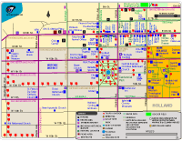
Downtown Holland Map (Online version)
Downtown Holland Map (PDF)
Attractions shown: Cappon House Museum, Civic Center, Holland Civic Theatre, Holland Museum, Hope College, Knickerbocker Theatre, and Park Theatre.
Parks included: Centennial Park, Hallacy Park, and Window on the Waterfront Park. There are two small pocket parks on 8th Street that feature sculptures.
Walking and Jogging Routes: The Historical Walking Routes will take you past historic locations and historical markers. There are rectangular markers posted on the several buildings, such as the Warm Friend Building and Fifth Third Bank Building, that describe when the building was constructed and other details. You can also visit many restaurants, stores and other locations in Holland via sidewalk.
Bike Routes: The bike routes shown are on streets that either have designated bike routes or have wide road lanes where cyclists can ride on the outside part of the lane.
Also shows Centennial Inn, City Flats Hotel, Eagle Building, Haworth Inn, Eighth Street Market, Herrick District Library, Holland City Hall, Holland Cycling & Fitness, Tulip Time Offices, City Flats Hotel, Convention & Visitors Bureau, Velo City Cycles, historic district, historical markers, sculpture locations, tulip garden locations, stores, restaurants, and more in Holland.
|
|
|
|
Western Holland Area Map (Online version)
Western Holland Area Map (PDF)
Trails shown: Part of Holland's paved trail system and the Riley Street Trails. Stu Visser Trails Park has a lengthy hiking trail and trailheads on Lakewood Boulevard and Ottawa Beach Road.
Parks shown: Black Lake Boardwalk, Holland State Park, Park Township Dog Park, Park Township Skate Park Park, Tunnel Park, Wendt Park, and Winstrom Preserve Park.
The map also shows Lake Macatawa Boat Access Site, Ottawa County Fairgrounds, Park Township Arts Center, and other locations.
|
|
|
|
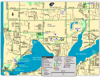
Holland Wide Map (Online version)
Holland Wide Map (PDF)
Attractions shown: Big Red Lighthouse, Nelis' Dutch Village, Veldheer Tulip Gardens, and Windmill Island.
Bike Routes shown: Shows streets with either designated bike routes or wide road lanes that have room for bikes to ride on the outside of lanes.
Trails shown: Holland paved trail system, which is used for biking, hiking, jogging, and roller blading. Also shows: Big Red Lighthouse Trail, Riley Street Trails, Sanctuary Woods Trail, Stu Visser Trails, Wolters Woods Park Trail, and Van Raalte Farm Park Trails.
Parks shown: Adams Street Landing, Beechwood Park, Dunton Park, Holland State Park, Maplewood Youth Complex, Paw Park Park, Quincy Street Park, Ransom Park, Sanctuary Woods, Smallenburg Park, Tunnel Park, Van Raalte Farm Park, Wendt Park, Window on the Waterfront Park, Winstrom Preserve, and Wolders Woods Park.
The map also shows GVSU Holland, the Ottawa County Fairgrounds, kayak launches, stores and restaurants.
|
|
|
|
Hospital Neighborhood Fitness Routes Map (Online version)
Hospital Neighborhood Fitness Routes Map (PDF)
On the south side of Holland, near the hospital, there are sidewalks designated at fitness routes for walking and jogging. The sidewalk route feature directional signage at street corners where the paths turn. The route pass several parks in Holland, including Michigan Avenue Park, Moran Park, Prospect Park, Rosa Parks Green, and Water Tower Park.
The map also shows streets that feature tulips in the spring and other notable locations.
|
|
|
|
|
Also see:
- Zeeland Area Trails
|
|