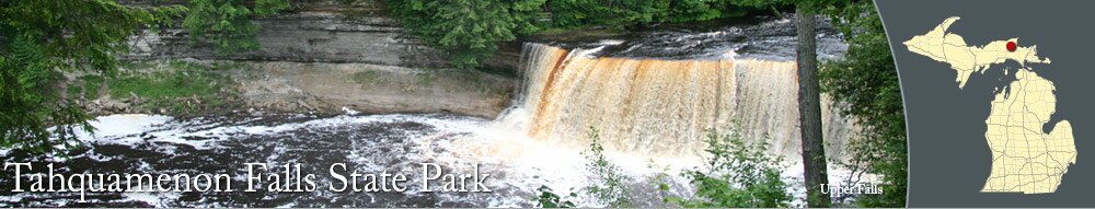
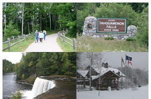
One of the most popular state parks in Michigan, Tahquamenon Falls State Park is known for its beautiful falls and miles of trails for hiking, cross-country skiing, and snowmobiling. The park attracts over 500,000 people annually and is home to many kinds of wildlife, including bears, moose, wolves, and 125 species of nesting birds.
Tahquamenon Falls
The Tahquamenon River flows 94 miles from the Tahquamenon Lakes into Lake Superior, and its falls are sometimes affectionately called "Root Beer Falls" because of the water's distinctive color. The flowing water has a rich, deep brown color, which is the result of tannic acid produced by decaying hemlocks, cedars, and spruces along the river's banks.
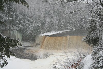
The Upper Falls is the third largest vertical waterfall east of the Mississippi River, following Niagara Falls and Cohoes Falls. The Upper Falls are over 200 feet across and drop about 48 feet, with a water flow of more than 50,000 gallons per second. The Upper Falls can be viewed at a couple of points along the Tahquamenon River Trail. You can also use stairs near the trail to climb down to a viewing platform for a closer view of the falls.
From the Upper Falls area parking lot, its a short walk to view the Upper Falls, using a wide paved trail that connects to the Tahquamenon River Trail. The route is wheelchair accessible.
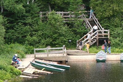
The Lower Falls are a series of waterfalls around an island in the Tahquamenon River. The Lower Falls can be viewed from the an area just off the Tahquamenon River Trail. It's approximately a half of a mile walk from the day use parking lot for the Lower Falls to the viewing platform.
You can get a different view of the falls by boat. Canoes and small boats can be rented for half-day or full-day use, and paddled around the river beyond the falls for a different perspective or rowed over to the island. On the island, there is a short hiking trail loop that provides several different views of the Lower Falls.
Hiking and Cross-Country Skiing Trails
Tahquamenon Falls State Park has miles of trails for hiking, cross-country skiing and snowmobiling. The trails offer an ever-changing landscape of natural beauty. Numerous kinds of trees, wildflowers, and wildlife can be seen around the park.
Before you head out, be sure that you're dressed appropriately for the weather conditions and pack food/water. Trails are not lit at night, so be sure you leave enough time to get to your final destination in the daylight. Also, you may want bug spray depending on the time of the year.
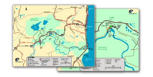
The Tahquamenon River Trail connects the Lower Falls and Upper Falls areas. The hiking trail is approximately 4 miles long and follows the path of the Tahquamenon River. It meanders through wooded areas and offers scenic views of the river.
North of the Upper Falls, there are several interconnecting hiking trail loops, which can be combined to create a longer hike:
- The Giant Pines Loop is approximately 3.5 miles long and is used for hiking and cross-country skiing. The trail loop starts near the Upper Falls from trail marker 1, goes northwest to trail marker 2, then curves northeast to trail marker 8 before going south towards trail marker 9 and the Upper Falls parking lot area.
- The Clark Lake Loop is about 5.6 miles long. The hiking trail starts at trail marker 6 and loops back to trail marker 6. The route shares two trail points with the Wilderness Loop. Trail markers 4 and 7 are intersection points for the Clark Lake Loop and Wilderness Loop, so be sure to follow the correct trail to avoid going on an unexpectedly long hike.
- The Wilderness Loop is almost 7.5 miles long and starts from trail marker 2 of the Giant Pines Loop. The long, curvy trail connects to the Clark Lake Loop at markers 4 and 7. It also connects to the North Country Trail at marker 3. Be sure to follow the Wilderness Loop trail from the markers to stay on the trail.
The North Country Trail is a hiking trail that extends across portions of Michigan, and a section of the trail can be used to hike from the east side of Tahquamenon Falls State Park to the Lower Falls area. The section starts near the Whitefish Bay Picnic area and ends up at the modern campground at Lower Falls area. The North Country Trail also connects to part of the state park's hiking trails, extending west from trail marker 3 of the Wilderness Loop.
Snowmobile Trails
The area around Paradise and Tahquamenon Falls State Park is a favorite destination for snowmobilers. From late December through March, the over 200 miles of groomed trails in the region offer a scenic ride and an abundance of snow.
You can fuel up at Tahquamenon General Store on M-123 (about a half-mile east of the Lower Falls area entrance) and at Paradise Recreational Sports in Paradise. Paradise Recreational Sports has snowmobile rentals.
Boating and Canoeing
At the Lower Falls area, canoes and small boats can be rented for half-day or full-day use, and paddled around the river beyond the falls for a different perspective or rowed over to the island at the center of the Tahquamenon River. From the Lower Falls area, you can canoe down the river to Whitefish Bay. In September, the Paradise Area Chamber of Commerce sponsors the Tahquamenon Wilderness Canoe Race.
On the east side of the state park, there are two recreational boat launches on Whitefish Bay.
Eating and Picnicking
Near the parking lot for the Upper Falls, the Camp 33 building is home to the
Tahquamenon Falls Brewery and Pub. Offering micro-brewed beers and tasty meals, the restaurant is definitely worth a visit. Steaks, shrimp, fish, burgers, salads, and much more are on the menu. The restaurant is open all four seasons, except when it closes in late fall and early spring. You can call ahead of your visit at (906)492-3300 to make reservations.
If you like picnics, there are several spots to gather for a bite:
- On the east side of the park, the Whitefish Bay Picnic Area offers a terrific spot for a picnic with a spectacular view of Whitefish Bay.
- Near the day use parking lot for the Lower Falls, there are picnic tables and a picnic shelter.
- South of the Camp 33 building at the Upper Falls area, there are a few picnic tables.
Camping
Tahquamenon Falls State Park features four campgrounds with modern and rustic campsites. Modern campgrounds are located in the Lower Falls area and on the east side of the park near Whitefish Bay.
Reservations can be made by calling (800)447-2757 or by making
reservations online.
Fishing
The section of the Tahquamenon River between the Lower Falls and Whitefish Bay is a popular spot for fishermen. Northern pike, walleye, and perch are prevalent in the river. When winter comes, ice fishermen like to drop their lines in Whitefish Bay.
A Michigan fishing license is required to fish on Michigan waterways, and you can get a license at Tahquamenon General Store, which is on M-23 just east of the state park. You can also purchase a license online at the
Michigan DNR E-License web site and at bait shops and sporting goods stores.
Neighboring Communities
Tahquamenon Falls State Park is located between Paradise and Newberry, which are both on M-123.
On the shores of Whitefish Bay, Paradise is a small village that has a few restaurants, a hardware store, and a couple of small shops. Several small hotels and a Best Western are the lodging choices in Paradise. Area attractions include Crisp Point Lighthouse, Whitefish Point Lighthouse, and the Great Lakes Shipwreck Museum. Cyclists can use an 11-mile bike route to ride from
Paradise to Whitefish Point Lighthouse.
Newberry is a larger community, located 28 miles southwest of the Tahquamenon Falls. Along M-123, there are several restaurants, bars, and stores, including grocery stores, pharmacies, and hardware stores. In case of a medical emergency, Newberry also has a hospital. Newberry area attractions include the Tahquamenon Logging Museum, Oswald's Bear Ranch and Luce County Historical Museum.